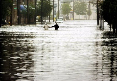
Rivers north of Boston
continue to rise, "triggering the worst flooding some areas have seen since 1936."
In Lowell, the rising Merrimack river may force "the closure of the historic Francis Gate for the first time since 1936." So how bad was it in 1936?
This won't come as any consolation to those folks in the Merrimack Valley and on the North Shore who are in shelters with their homes under water, but the "Flood of '06" (as Ken Barlow was breathlessly calling it on channel 4 last night) is a fairly tame event compared to the flood that ravaged nearly all of New England 70 years ago.
I'll have to be honest, I hadn't even heard about the Great Flood of 1936 until a couple of weeks ago, when the
Times-Courier ran a column by local historian (and AUC classmate) John Schumacher-Hardy looking back at the disaster. I was surprised to read about the magnitude of the flood since I'd never heard my grandfather or grandmother talk about it. They used to tell stories of the devastation wrought by the 1938 Hurricane, but I'd never heard of this flood. It was pretty bad in Lancaster:
On Wednesday evening, March 18, [1936,] the north branch of the Nashua River was rising at a rate of one foot per hour. It rose so quickly by Bennett Bridge on Route 117 that Phoebe Lovely had to be rescued by row boat in the night. Her house, currently the residence of Town Clerk Sue Thompson, was last on the right before the bridge, traveling west.
Arletta Ross, who was 10 years old at the time and living on Otis St., well remembers how her father, Horace Johnson, and neighbor Eliot Hamilton had to carefully row the boat down Main Street (Rt. 117) to fetch poor Mrs. Lovely. The waters had risen so high, Ross explained, that they had even covered the small park in North Village.
The Thursday, March 19 Clinton Daily Item reported: "It is a weird and awesome sight in Lancaster, today, as the town is virtually an island, the only opportunities for its citizens to reach Clinton being to walk across the old bridge of the Worcester Consolidated Street Railway, adjoining Vose Bridge, or to utilize the B. & M. R. R. bridge across the North Branch of the Nashua, from Lancaster Center depot."
In those days there was no Route 70. That stretch of highway that juts north out of North Village by the corner of the former Fairbanks-Dwyer Inn hadn't yet been built. The only roads in or out of Lancaster Center and North Village were Main Street, Center Bridge Road, Seven Bridge Road and the then-open Shirley and Harvard roads.
All these automobile routes had become impassable due to the heavy flood. If their bridges weren't washed out entirely, as in the case of the old iron Center Bridge, then they were too weakened to be safely traversed. The road along the low-lying stretches of the other routes had been completely submerged.
Chet Locke, Sr., still currently living in Lancaster Center, was a lad of 12 years old at the time. Locke vividly recalls looking out from the back of his Main Street home, over the field behind there, and seeing what "looked like a huge lake." The entire valley between Lancaster Center and George and Ballard hills had filled with the flood waters. He also noted, when the waters finally did subside in the following weeks, large chunks of ice littered the entire vast meadow plain for weeks more until they finally melted.
I consider myself very familiar with town, and I cannot envision a flood of this size. I've seen Bolton Road, Center Bridge Road and Seven Bridge Road (Rte. 117 east into Bolton) under water at various times, and it's not unusual to see the south bank of the Nashua River overflow into the valley between Main Street and Langen Road.
But the river would need to be three or four feet higher that I've ever seen to overflow the bridge on 117 west toward Ballard Hill, and even higher than that to encroach the bridge south out of the center of town. It's unfathomable that there was so much water in town that it covered the green in North Village.
Even so, Lancaster got off easy compared to much of the rest of New England.
Over 430,000 people were left homeless in the
Connecticut River Valley. Much of Manchester, NH was under water in what is called
the worst flood in the state's history.
Over 150 New Englanders died and the storm did between $250 million and $500 million in damage (
in 1936 funds).
Not only was New England affected, but the entire northeast from the Ohio River Valley to Washington DC and north to Canada was affected by flood in March of 1936. The floods were largely responsible for giving Congress the impetus to pass the
1936 Flood Control Act. Policies implemented because of the act have been credited with mitigating some of the damage due to the current flood.
If you listen closely, there are still a few people out there who are aware of the impact of the Great Flood of 1936. On WBZ radio this morning, the mayor of Haverhill said that while much of his city is under water, his parents report that this flood is nothing compared to what they experienced in 1936. And on his weather blog,
Matt Noyes of NECN (who is the best forecaster on TV today) explained "In some areas around the Merrimack Valley, record flooding is forecasted by the River Forecast Center. It's important to note that for many of these areas, those records do not go back as far as the Great Flood of 1936, and flooding of that magnitude is not expected."
For more on the "Flood of '06,"
Universal Hub has been posting reports and photos from area bloggers for the last few days.
Tags: Massachusetts Lancaster flood 1936 2006
