A couple of weeks ago, I came across this web application that allows the use to create congressional district maps with accurate information from every voting precinct in the country. As you assign precincts to a district, it calculates the population in the proposed district and the deviation from the perfect district size...the thing is absolutely incredible.
As you can imagine, I've been geeked up on this thing, creating different scenarios for Massachusetts when we come up for redistricting in 2012. So far, I've run four scenarios. In all of them, I'm assuming that Massachusetts will be left with just nine districts, which means that one congressional seat has to vanish. In three of the four scenarios, I'm also assuming that incumbents will remain in their districts and that the Democratic legislature is the ones doing the redistricting.
The first scenario I ran is one that has been seen as likely ever since it became clear that Massachusetts would lose a district. There has been speculation that 1st District Representative John Olver might retire after the 2011-12 session, allowing the first district to be the one that is dissolved. Here is the way I would redistrict the state based on that assumption:
Here, I've combined the western parts of the first and second districts to create one district that is essentially the Connecticut River Valley and the Berkshires. To compensate for that, I've moved Jim McGovern's district north and west, to include most of the populated areas of Worcester County west to the liberal bastion of Amherst. The southern leg of McGovern's old district is now split between Ed Markey and Barney Frank. Finally, I've extended Niki Tsongas's district west along the NH border, giving her a district where most of her population is in the Merrimack Valley and most of her land area is in the rural north.
In scenario 2, Niki Tsongas is defeated by a Republican challenger (not necessarily likely, but she is probably the most vulnerable to a challenge).

In this case, I have carved up the old fifth district into the first, third, fourth, sixth, and seventh districts, essentially leaving the old district with no base on which a Republican incumbent could run. I've also put Carlisle--home of top Republican candidate Jon Golnik--into the district of powerful Rep. Jim McGovern, along with urban centers like Worcester, Fitchburg, Leominster, Marlborough, and Lowell. Actually, this isn't a bad map at all.
There has been a lot of buzz over challengers to Bill Delahunt in the 10th district. In scenario 3, I combine the ninth and 10th districts, forcing a Republican to have to run against Conservative Boston Democrat Steven Lynch to retain his seat.

This scenario forces some pretty significant gerrymandering south of Boston and in Metro West (for instance, the 40 miles from Grafton to Logan Airport would take one across seven districts). I don't really like this solution, but the legislature will do what it has to do to give a Democrat the chance to retake the seat.
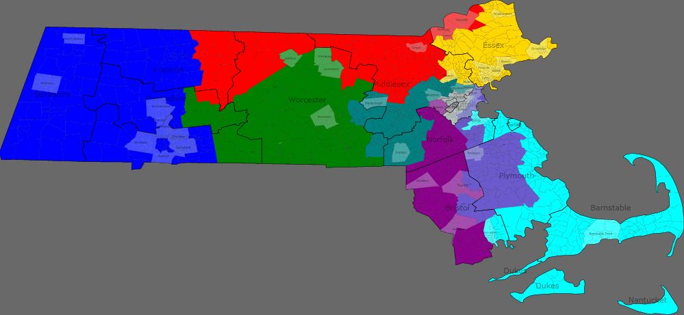
Finally, I gamed out a district map with no regard to incumbency or current borders:

District 1 would be Springfield and the Berkshires. District 2 is Central Mass. and the Quabbin region to Amherst. District 3 is the 495 belt. District 4 is the Merrimack Valley. District 5 is 128 and Metro West. District 6 is the North Shore. District 7 is Boston and Quincy. District 8 is 95 South, and District 9 is the South Shore, South Coast, and the Cape and Islands. I really like this.
Oh, and since you can set the number of districts you want in the application (up to 500), one could also game out maps for the 40 State Senate and 160 State Representative Districts. But even that might be a little too geeky for me.

